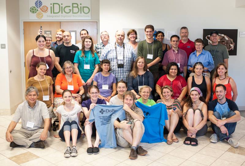
From across the continent, a diverse group of 26 participants, 10 remote participants, and five instructors gathered in Gainesville from August 12 – 16 for a week-long intermediate to advanced course on georeferencing natural history museum legacy specimen data, emphasizing how to present and teach these skills to others.
On the iDigBio Wiki, all TTT2 course materials are now available for anyone to use, including recordings of the presentations. Please see our TTT2 wiki, TTT2 participant list, TTT2 Course Topics Summary List, Training Videos on Vimeo, and photos on facebook for details. Join our listserv to continue the geocoding discussions.

Prior to the workshop, participants were invited to attend a pre-workshop remote session using Adobe Connect. We got to meet each other, ask questions about the up-coming workshop, and learn to navigate Adobe Connect. Participants at the workshop were then prepared to interact with the remote participants, and use this communication tool at and after the workshop for future collaboration. (We needed it even sooner than we would have guessed!, read on)...

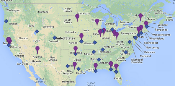
Participants ranged from undergraduates to retired faculty and came from all over the USA (kml version). On the map, those attending TTT2 are shown in blue, those in purple are from TTT1 (October 2012, see TTT1 blog post, TTT1 wiki, participant list, photos on facebook).
Instructors included: Dave Bloom, Nelson Rios, Una Farrell, Jessica Utrup, Deborah Paul and Michelle Vanderwel. One of the goals of iDigBio's Georeferencing Working Group (GWG) is to help create a national resource of individuals ready and willing to train others to georeference. Jess and Una were participants at iDigBio's 1st Train-the-Trainers workshop and were chosen by the GWG to be instructors at TTT2 and they are now part of this national network.
On Day One, we began with one slide lightning talks (large pptx file) for everyone to meet each other and see the scope of nation-wide georeferencing efforts in museum collections. After an overview of iDigBio by Deb, Dave introduced everyone to just what georeferencing is and why we need more individuals skilled at teaching others to georeference millions! of legacy locality records. Next, Nelson presented the basics of geographical concepts so we all know the difference between and importance of projections, datum, and coordinate systems. Jess explained what uncertainty is, where it comes from and how to accurately represent it using the point-radius method.
Uncertainty: The sum of what we know…about what we don’t know…is the uncertainty.
In what was review for some and a first time introduction for others, Dave explained data standards, the Darwin Core Standard in this case, and the agreed-upon terms we need to use from a given standard to share georeferencing data (and other data), meaningfully. Many of us discovered that our databases need some fields added to store data for some of these concepts. All of us recognized that often, some of this data is not currently being collected in the field. Everyone at this workshop can now spread the word and share best practices for what georeferencing data to collect in the field. Just after lunch, Una reviewed different locality types and how to use the georeferencing template and Dave followed up with how to use the georeferencing calculator. Our day was complete, everyone's brains were full and looking forward to dinner and a evening off before Day Two.

A TTT2 group photo started off Day Two. We reviewed internet resources and discovered new ones to use to georeference some challenging localities, met the GPS challenge to find 5 waypoints and attempted to write a "good locality description." At the end of the day we reviewed the issues of using paper maps (skills we would need for Day Three). We got participants input on mapping features they'd like to see on the iDigBio portal and asked everyone to document their own project's workflow (to share on Day Three).
On Day Three, our morning began with paper maps and the challenge (and fun!) of trying to find places on maps with localities with which we are not familiar. Sure makes you appreciate online resources. Later, the focus turned to georeferencing workflows across different software platforms including KE EMu (Jess), Specify (Una), and Symbiota (John Brinda, participant). Jess, Una, Nelson, Dave and Deb all discussed different facets of this topic including: idiosyncrasies of a particular software package (for georeferencing) and what fields one can record (or not), the possible options for collaborative and bulk georeferencing, getting collaborative or bulk georeferences back into a particular database, and the need to document workflows. In addition, the topic of just how much training someone needs in order to produce fit-for-research-use georeferences from legacy locality data was discussed. To help answer this question more definitively, Dr. Austin Mast (FSU) and Dr.Gil Nelson (also from FSU) are carrying out some comparative experiments looking at locality data georeferenced by an expert side-by-side with the same locality data georeferenced by undergraduate students. Stay tuned for their results! To wrap up our third day, Danielle Pace (AMNH), Katrina Menard (Sam Noble Museum) and Mark Uhen (paleodb.org), volunteered to share their workflows. Thank you! Do you have georeferencing workflow documents you'd like to share with the community? We'd like to post them to our wiki for everyone to benefit. Contact any of us in the GWG.
Participants, in five small groups, attempted to locate GPS waypoints on Day Two and strived to write "good" locality descriptions. (Not easy!) On the morning of Day Four, everyone's GPS data from all five groups, collated by Dave, Jess and Una, found its way onto a map. Very enlightening to visualize these points (we need to do this with our data!) and while most points were quite good, those that were off were usually easy to explain. Dave reviewed the importance and nuances of a good locality description to support the GPS data collected and shared a best practices field locality handout for what locality data to capture when working in the field. Spread the word! Next up, Michelle Vanderwel shared what she has learned from her on-going work for FishNet2 as a georeferencing technician. Nelson then covered using GEOLocate, from the novice to the expert and how to georeference collaboratively. We need lots of georeferencers given the scope of the task!
On the evening of Day Four, we headed out in two vans for the La Chua Trail at Paynes Prairie to see a bit of nature and get out of the classroom (Thanks Grant). You can see some of our photos of natural Florida and great shots of some live specimens. While it was very warm, a good time was had by all and after our hike we took our appetites and headed for downtown Gainesville and a well-earned dinner!
Nelson found the time too short to cover Advanced GEOLocate (link to video) so we scheduled a follow-up tutorial and recorded the session using Adobe Connect. This one hour IT-focused lecture covered technical aspects of GEOLocate webservices (SOAP, JSON) using cURL, using RStudio, embedding GEOLocate & services, and more. Over 30 people attended remotely and you can listen to this lecture for yourself and get the details in the online report. Are you interested in embedding GEOLocate into your application? Would you like to know more about setting up collaborative georeferencing? Nelson is ready and willing to help.
Day Five meant it was time to talk about data, specifically about cleaning, processing and analysis of data. Participants were introduced to a new tools for cleaning data (openrefine.org) and shown examples of how to use a web service to enhance their data, for example: returning georeferencing data or validating taxonomic names. Nelson explained what can be done using tools like r-project, RStudio, QuantumGIS and QGIS (see Advanced GEOLocate Adobe Connect video for more about this). Next, four adventurous participants willingly volunteered to become instructors and presented their own Training Demos. See: Georeferencing the Star Herbarium by Kari M. Harris, Arkansas State University; How to Make a Good Insect Specimen label …and why by Edward G. Riley, Texas A & M University; What does Antarctica really look like? Projections are important… by Sharon Grant, The Field Museum; and Digitizing Collections of the Angelo State Natural History Collections by Marcia A. Revelez, Angelo State Natural History Collections. John Brinda, from Missouri Botanical Garden, also stepped in with a live demo to review how batch georeferencing is done inside the Symbiota data portal. Then it was time for participants to work with their own datasets. We all wish there was a Day Six! just for this. Once you are working with your own data, everyone discovers different issues that need work.
This workshop would not be possible without the collective experience and collaborative efforts of the iDigBio Georeferencing Working Group (GWG). Many thanks to all in the GWG. It was great to get to spend five days together - plenty of time to nuture new friendships, pursue new avenues for collaboration and figure out next georeferencing steps. We look forward to everyone's feedback and upcoming efforts to pay-it-foward and get more people involved in georeferencing. Won't you join us?


