by Mike Yost, iDigBio GWG member and MaCC TCN Project Assistant
Introduction.
Greetings fellow georeferencers! Mike Yost here, MaCC Project Assistant and blogger of all things georeferencing.
With the ubiquity of smart phones, GPS apps have the potential to increase efficiency in gathering locality data for biological specimens. These apps provide a host of options and features not available on some hand-held GPS devices, and most of these apps are free to download and use, saving costs in purchasing additional hand-held GPS units. But how accurate are these GPS apps? Do they offer the same convenience and utility as hand-held GPS devices? What protocols and best practices should be developed if an institution decides to implement the use of a GPS app?
The iDigBio Georeferencing Working Group (GWG) recently spearheaded a project to answer those questions. (Click on the above link to read the project description for the GPS Apps Data Project). The iDigBio GWG, of which I am a member, collected locality data at various locations across the USA using several different GPS apps, comparing the lat/long coordinate results with those established at the same location using a hand-held GPS device. The results were consolidated and analyzed in order to determine which apps were the most accurate, the most efficient, and the most user friendly.
This article is a delineation of my own experience as part of that experiment, reviewing the pros and cons of the GPS apps that we tested, the results generated by each app, and (for me) which app was the easiest to use and the most accurate.
My hope is that this will assist other institutions in drawing up their own protocols and best practices when deciding which GPS apps to use in documenting and collecting accurate locality information.
NOTE: Check with your project manager before using any of the GPS apps as the source of establishing specimen locality data at your herbarium.
So with that said, let’s begin by reviewing the four apps we tested.
Comparing GPS Apps.
For our experiment, GWG tested the following four GPS apps, all of which are free and available for both Android and Apple platforms. (Click on name to open up app link.)
Let’s walk through each app, outlining how intuitive and useful they were to use. Their accuracy will be discussed in the next section.
![]() GPS Status
GPS Status
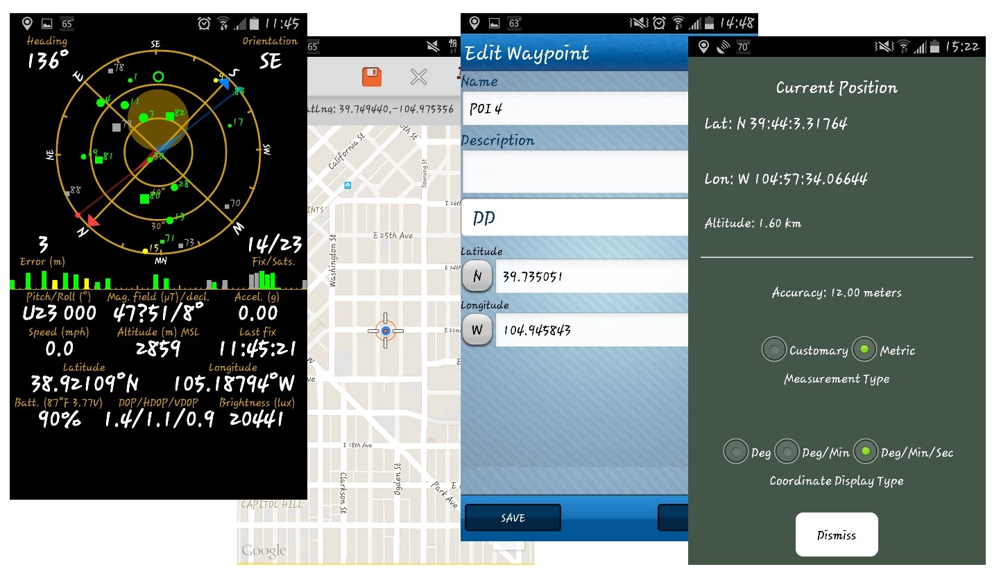
GPS Status displayed all of the GPS data on my phone onto a single screen, including the number of locked GPS satellites, the accuracy offset measured in meters, and elevation—information that was not always available on the other GPS apps we tested.
This was one of my favorite apps because it was quick to display the locality information and extremely easy to use. I didn’t need to navigate through menus or maps to find my locality data, as all the necessary information was immediately displayed on a single screen. In addition, there were multiple location formats available (including UTM), and a helpful nighttime display option for collecting in low-light environments. However, with GPS Status, I had no access to a map to show me visually where my position was. As a result, there was no way to save a waypoint—a helpful feature with some of the other GPS apps.
I saved the locality data by taking a screenshot at the collection site, confident all the required information was ready to be accessed and transcribed later once I was at my computer.
Pros:
- Simple and easy to use.
- All information displayed on a single screen.
- Displays number of locked satellites, elevation, and accuracy offset.
- Nighttime display.
Cons:
- No access to a map to show location.
- No ability to save or share waypoints.
![]() Trimble Outdoors Navigator.
Trimble Outdoors Navigator.
Trimble had more options, but wasn’t as intuitive as GPS Status. To find my lat/long coordinates, Trimble displayed my location as a blue icon on a map (which also indicated the direction I was facing). I had to touch the blue icon to start and save a trip, then I had to touch the blue icon again. A menu popped up where I could save the waypoint to the trip I just created, and then the app (finally) displayed my lat/long coordinates.
Unlike GPS Status, Trimble provided a helpful map that displayed my position, and there were multiple layers I could apply to the map such as terrain, topo, and hybrid street views. There were also overlays available (including custom overlays), but these options were only available with the paid version. I’m a poor college graduate, so I didn’t explore those options. In addition, Trimble not only allowed me to save waypoints, but also gave me the option to create a trip or path to the collection site which I could then share with others—though the others will need the same app to access that information.
I also had the option of taking pictures, videos, and audio samples, saving the files to the waypoint on the map, and Trimble provided multiple positioning formats such as UTM, DD, DMM, DMS, and others. However, Trimble didn’t provide information on the number of satellites being used to pinpoint the location, nor could I find any information on my elevation or the accuracy offset.
Pros:
- Access to map with multiple layers and overlays.
- Ability to save waypoints and share data with other Trimble users.
- Ability to take pictures, videos, or audio files and save to waypoint.
Cons:
- No access to information on number of locked satellites, elevation, or accuracy offset.
- Not as intuitive as GPS Status.
![]() Wolf-GIS.
Wolf-GIS.
Of the four apps I tested, this program was the least intuitive (for me) in finding my lat/long coordinates. It worked by displaying my position on a map as a blue icon. (Why are the icons always blue?) In order to find the lat/long coordinates of that position, I had to move a set of crosshairs over the icon on the map. Then the crosshairs displayed the lat/long coordinates at the top of the screen.
The problem I ran into was that often my position on the map would move from one spot to another by several meters (even though I was standing motionless). I would move the crosshairs over the blue icon, then the position would jump to another location. This of course made gathering locality data more time consuming and rather frustrating at times—especially when compared to apps like GPS Status which immediately displayed my lat/long coordinates.
As with Trimble Navigator, Wolf-GIS did provide a number of map layers and overlays, as well as options to measure distances from a waypoint and save those waypoints to the phone. However, Wolf-GIS didn’t provide elevation, accuracy offset data, nor the number of satellites locked to determine location. In addition, this app seemed to be the biggest battery drainer of the four GPS apps used
Pros:
- Access to map with multiple layers and overlays.
- Ability to save waypoints.
- Option to measure distances from waypoints.
Cons:
- No access to data on number of locked satellites, elevation, or accuracy offset.
- Inefficient and sometimes difficult to use and find lat/long coordinates.
- Battery drainer.
![]() Free GPS.
Free GPS.
Similar to the GPS Status app, Free GPS was simple and easy to use, displaying all the necessary data on a single screen. As with most of the other apps, Free GPS had multiple formats for lat/long coordinates including Deg, Deg/Min, and Deg/Min/Sec (though there was no option for UTM). But unlike GPS status, Free GPS did provide a map which contained several available map layers including street, satellite, and hybrid templates. In addition, I had the option of saving waypoints to the phone.
And unlike Trimble Navigator and Wolf-GIS, Free GPS also provided elevation and accuracy offset information. However, it didn’t display the number of locked satellites being used to determine my position. Also, as with any free app, advertisements sometimes popped up on the screen of which I had to clear in order to continue working.
Pros:
- Simple and easy to use.
- All locality information displayed on a single screen.
- Access to a map with multiple overlays.
- Ability to save waypoints to phone.
- Displays shows elevation and accuracy offset.
Cons:
- No information on number of locked satellites.
- No access to UTM data.
- Ad pop-ups.
Efficacy.
So which of these apps was the most efficient in gathering lat/long coordinates? I liked both Free GPS and GSP Status the most. They were quick and easy to use, displayed all the necessary information on a single screen, and I wasn’t forced to navigate through multiple menus or screens to obtain my locality data. The added feature of a map on Free GPS made this my favorite app when it came to efficiency.
However, efficacy doesn’t matter if the app isn’t accurate. So how did these four apps perform regarding accuracy? Let’s look at the results at five different locations in Colorado.
Comparing Lat/Long Results.
Before I delineate my lat/long results for each GPS app, I want to first outline a quick summary of the equipment used, take a look at the parameters the GWG established for this project, and review a few caveats:
Equipment Used.
- Phone Model: Samsung Galaxy S4
- Phone OS: Android (Version 4.4.4)
- Service Provider: T-Mobile
- GPS Device (for locations 1,2, and 3): Magellan GPS 315
- GPS Device (for locations 4 and 5): Garmin etrex Vista HCx
Parameters and Caveats.
Wi-Fi v. Service Provider Network: We generated two sets of lat/long coordinates for each GPS device at each location—one set with Wi-Fi enabled and one set with Wi-Fi disabled.
NOTE: The general consensus is that lat/long coordinates are more accurate when the smart phone is connected through a Wi-Fi connection rather than through the service provider’s network. We wanted to put that consensus to the test.
Standard of Comparison: As I began gathering data, I quickly discovered that the Magellan GPS hand-held device I was using was sometimes a few meters off from my actual physical location (which was part of the reason I used a different GPS device for locations 4 and 5). So, I recorded not only the position provided by the GPS device, but I also displayed on the map where I was standing when I took the measurements.
As you’ll soon see below, I compare the results of the GPS apps to my physical location as well as the location generated by the GPS hand-held device.
Mapping and Legend: After I recorded the lat/long coordinates at five different locations, I plotted each point on Google Maps, then converted that information to a KML file I could open and explore using Google Earth. For this section, the screenshot for each location was taken using Google Earth to plot the lat/long coordinates.
I also created a legend for the map (below), with each GPS app represented by a specific shape and color. In addition, I differentiated between Wi-Fi enabled and Wi-Fi disabled with a lighter shade of color for the former.
Legend:
- Gray Waypoint = Hand-held GPS Unit
- White Waypoint = Physical Location
- Purple Circle = GPS Status (no Wi-Fi)
- Light Purple Circle = GPS Status (Wi-Fi)
- Blue Square = Trimble Outdoor Navigator (no Wi-Fi)
- Light Blue Square = Trimble Outdoor Navigator (Wi-Fi)
- Red Star = Wolf GIS (no Wi-Fi)
- Light Red Star = Wolf GIS (Wi-Fi)
- Green Diamond = Free GPS (no Wi-Fi)
- Light Green Diamond = Free GPS (Wi-Fi)
So with that, let’s move forward and look at the results of my first location.
Location 1: Behind house along York Street in Denver, Colorado
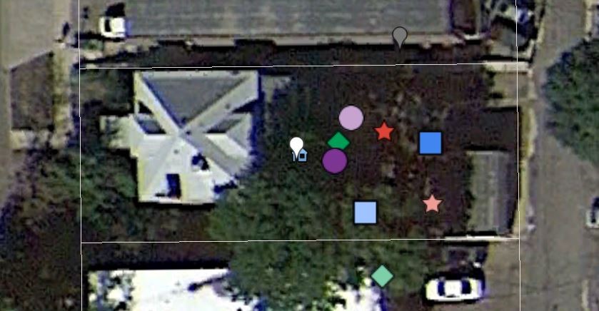
- Most accurate (compared to physical location): GPS Status (no Wi-Fi)
- Least accurate (compared to physical location): Free GPS (Wi-Fi)
The first location I gathered locality data at was behind a home along York Street in Denver just north of the Botanical Gardens. My physical location is marked by the white waypoint.
Weather. It was a partly cloudy to cloudy day, and it rained shortly after I took these readings. As you can see in the picture above, even the hand-held GPS device (marked as the gray waypoint) was less accurate than some of the GPS apps—as compared to my physical location. One additional variable that should be noted is the GPS device is an older 2002 Magellan model, which could account for the high offset.
The most accurate result (as compared to my physical location) came from the GPS Status app with the Wi-Fi disabled (purple circle). This was followed closely by the Free GPS app, also with Wi-Fi disabled (green diamond). The least accurate result came from the Free GPS app with the Wi-Fi enabled (light green diamond), followed by the Wolf-GIS app with Wi-Fi enabled (light red star).
It’s not looking good for Free GPS or Wolf-GIS. But before I jump to any conclusions, let’s continue to look at additional locations.
Location 2: In Front of Under the Umbrella Café and Bakery at 12th St. and Madison in Denver, Colorado
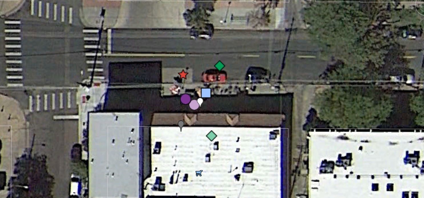
- Most accurate (compared to physical location): GPS Status (Wi-Fi)
- Least accurate (compared to physical location): FREE GPS (Wi-Fi)
My second location was in front of a business called Under the Umbrella Cafe and Bakery. (And if you happen to find yourself in Denver, definitely check out this great local coffee shop. They have pumpkin-chocolate-chip cookies and bottomless cups of coffee. Enough said). It was another overcast day when I took these results, and you can see that the hand-held GPS coordinates were not as close to my physical location as some of the GPS apps.
The most accurate result (as compared to my physical location) was the GPS Status app with the Wi-Fi enabled (light purple circle), followed closely by GPS Status with the Wi-Fi disabled (purple circle) and the Trimble Outdoor app both with the Wi-Fi enabled (light blue square) and disabled (blue square under the purple circle). The least accurate results were from Free GPS, as both the Wi-Fi enabled and disabled results (light green diamond and green diamond) were almost equidistant from my physical location.
It looks as if Free GPS is losing the accuracy race. But we’re only two locations in, so let’s see if the app can pull ahead in the next location.
Location 3: Balcony of residence along 22nd Street in Denver, Colorado
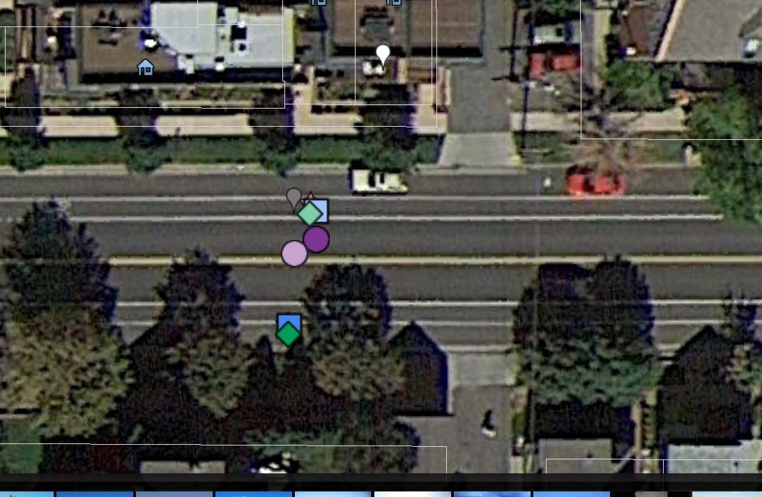
- Most Accurate (compared to physical location): Wolf GIS (Wi-Fi)
- Least Accurate (compared to physical location): Free GPS (no Wi-Fi)
I collected lat/long data at this location at a private residence on the balcony of the second floor while it was raining (you’d think I live in London with all this rain and cloudy weather). As you can see in the image above, the precision was much tighter at this location, even though the accuracy as a whole had me standing in the middle of the street—not a good place to collect mushrooms by the way.
This time the most accurate result (as compared to my physical location) came from Wolf GIS with Wi-Fi enabled (light red stare beneath the light blue square), followed closely by both Trimble Outdoor app and Free GPS (light green diamond), both with Wi-Fi enabled. The least accurate results came from Free GPS with Wi-Fi disabled (green diamond), followed closely by the Wolf-GIS app with Wi-Fi disabled (blue square).
It’s not looking good for Free GPS, as the program has generated the least accurate lat/long results for the last three locations. The crowd is on the edge of their seats to see what happens at the next location!
Location 4: In front of St. Marks Coffee House along 17th Street in Denver, Colorado
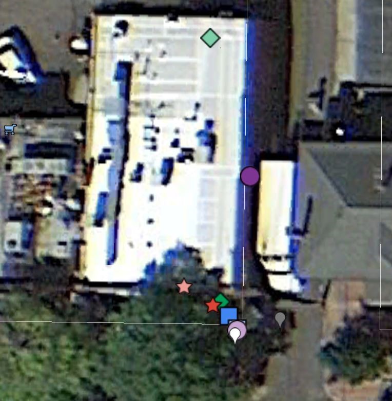
- Most Accurate (compared to physical location): GPS Status (Wi-Fi)
- Least Accurate (compared to physical location): Free GPS (Wi-Fi)
This location was in front of a place called Saint Mark’s Coffee House. (No bottomless coffee here, but they serve excellent beer and feature a cozy fireplace!) I should note the Wi-Fi service was a bit spotty on the outside patio at this location. However, I was able to capture lat/long data, and GPS Status with Wi-Fi enabled (light purple circle) was the closest to my physical location, followed closely by Trimble Navigator with the Wi-Fi disabled (blue square under light purple circle).
Once again the least accurate results came from the Free GPS app with the Wi-Fi disabled, placing me almost behind the coffee shop. However, GPS Status with the Wi-Fi enabled (purple circle) also placed me inside the coffee shop, several meters away from my physical location. It’s not looking good at all for Free GPS, so let’s see what happens at my final location in the mountains near Divide, Colorado.
Location 5: Back of house near Divide, Colorado.
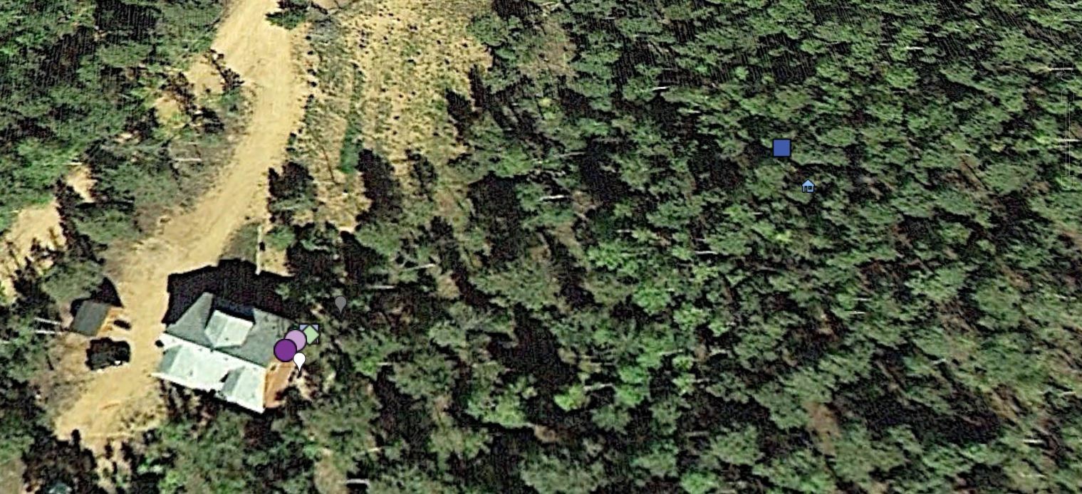
- Most Accurate (compared to physical location): GPS Status (no Wi-Fi)
- Least Accurate (compared to physical location): Trimble Outdoor (no Wi-Fi)
I took these results at the back of a house near a small (small) mountain town called Divide. Again, the most accurate GPS app was GPS Status with Wi-Fi disabled (purple circle), followed closely by the GPS Status with Wi-Fi enabled (light purple circle). It’s here that Free GPS finally redeems itself, stacked under the light purple circle (see below):
You’ll notice Free GPS with Wi-Fi disabled and Wolf GIS with Wi-Fi disabled were almost in the same location as GPS status. The least accurate was Trimble without Wi-Fi (blue square), which positioned me several meters away from my physical location. This was possibly an anomaly, as Trimble wasn’t usually this inaccurate.
Enough with locations and shapes on maps, right? Bottom line, which GPS app was the most accurate?
Final Summary of Results
- GPS Status was the most accurate at four out of the five locations.
- Two out of those four results were generated with Wi-Fi enabled.
- Free GPS was the least accurate at four out of the five locations.
- Three out of those four results were generated with Wi-Fi enabled.
Conclusion
Though Free GPS was user friendly, intuitive, and featured a map I could access to show my location, the results were consistently the least accurate of the four GPS apps—even with Wi-Fi enabled. For me, my vote goes with GPS Status, which was the most accurate of the four GPS apps and easy to use. Access to a Wi-Fi network split the results, with two locations more accurate with Wi-Fi than without.
The only possible issue regarding GPS Status is that the app doesn’t provide a map where you can view your location or save a waypoint.
So, GPS Status gets a gold star. *Applause*
Free GPS gets a threadbare participation ribbon. *Silence*
Note that I’m making overall conclusions with only 5 locations, and that Free GPS was sometimes in second or third place at some locations when it came to accuracy. Also, there are additional variables to consider such as the type of phone used, the phone’s OS, service provider, network strength, Wi-Fi connectivity and strength, and of course access to bottomless cups of coffee.
I encourage you to experiment with these four apps and discover if you can generate similar results. Hopefully this information will help if you decide to implement the use of GPS apps at your institution. There will be additional blogs on this epic battle between GPS apps v. GPS units coming soon from other members of the iDigBio GWG. In the meantime, what about you? Do you use GPS apps in the field? If so, which app works for you? What do you recommend?
Thanks for reading, and happy georeferencing!
Mike Yost
MaCC Project Assistant and occasional Georeferencing Scribe.


