{
"uuid": "efc051a9-b7b2-43ee-9768-4f35b436d8ef",
"type": "records",
"etag": "f9f99702b7c4bf7d820b10055090cf83fd2bc830",
"data": {
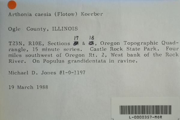
"dwc:specificEpithet": "caesia",
"dwc:county": "Ogle",
"dwc:recordedBy": "Michael D. Jones",
"dwc:georeferenceSources": "2016-01-14; Robert Anglin script for Township Range Section in GeoLocate",
"dwc:order": "Arthoniales",
"dwc:habitat": "in ravine; on Populus grandidentata",
"dwc:scientificNameAuthorship": "(Flotow) Körb.",
"dwc:occurrenceID": "4c8df5d1-f8d8-4c01-9bd5-17c489cb35e3",
"dwc:verbatimCoordinates": "TRS: T23N R10E Sec. 17 & 18",
"id": "1415695",
"dwc:taxonID": "52404",
"dwc:stateProvince": "Illinois",
"dwc:eventDate": "1988-03-19",
"symbiota:recordEnteredBy": "kelueders",
"dwc:collectionID": "36ea544b-df08-4f21-80e5-dd1c0bdc39c6",
"dwc:country": "U.S.A.",
"dwc:georeferenceRemarks": "lat/long = TRS; uncertainty = extent of Section",
"dwc:higherClassification": "Fungi|Dikarya|Ascomycota|Pezizomycotina|Arthoniomycetes|Arthoniomycetidae|Arthoniales|Arthoniaceae|Arthonia",
"dwc:kingdom": "Fungi",
"dwc:decimalLatitude": "41.981742",
"dwc:basisOfRecord": "PreservedSpecimen",
"dwc:genus": "Arthonia",
"dwc:family": "Arthoniaceae",
"dc:rights": "http://creativecommons.org/licenses/by-nc/4.0/",
"symbiota:recordID": "4c8df5d1-f8d8-4c01-9bd5-17c489cb35e3",
"dwc:phylum": "Ascomycota",
"dcterms:references": "https://lichenportal.org/portal/collections/individual/index.php?occid=1415695",
"dwc:locality": "Oregon Topographic Quadrangle, 15 min series. Castle Rock State Park. Four miles southwest of Oregon Rt. 2, west bank of the Rock River.",
"dwc:institutionCode": "MOR",
"dwc:taxonRank": "Species",
"dwc:class": "Arthoniomycetes",
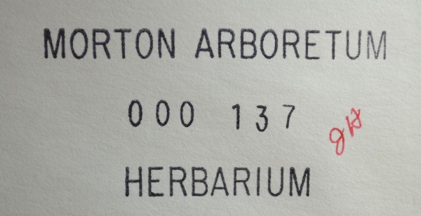
"dwc:catalogNumber": "L-0000357-MOR",
"dwc:Identification": [
{
"dwc:identifiedBy": "unknown",
"dcterms:modified": "2023-04-25 01:28:23",
"dwc:specificEpithet": "caesia",
"idigbio:recordID": "urn:uuid:6a3cd613-f75a-4ae8-b99a-02c663cdf80c",
"coreid": "1415695",
"dwc:scientificNameAuthorship": "(Flotow) Körb.",
"dwc:dateIdentified": "s.d.",
"symbiota:tidInterpreted": "52404",
"dwc:genus": "Arthonia",
"dwc:scientificName": "Arthonia caesia"
}
],
"dwc:decimalLongitude": "-89.366859",
"dwc:coordinateUncertaintyInMeters": "1100",
"dwc:otherCatalogNumbers": "000137",
"dwc:georeferencedBy": "ranglin",
"dwc:recordNumber": "1-0-1197",
"dcterms:modified": "2023-04-25 01:43:19",
"dwc:scientificName": "Arthonia caesia"
},
"indexTerms": {
"geopoint": {
"lat": 41.981742,
"lon": -89.366859
},
"family": "arthoniaceae",
"recordset": "99b04c9f-908e-42bd-92bc-41aa94b72949",
"dqs": 0.30434782608695654,
"stateprovince": "illinois",
"county": "ogle",
"phylum": "ascomycota",
"catalognumber": "l-0000357-mor",
"startdayofyear": 79,
"taxonrank": "species",
"specificepithet": "caesia",
"continent": "north america",
"uuid": "efc051a9-b7b2-43ee-9768-4f35b436d8ef",
"countrycode": "usa",
"basisofrecord": "preservedspecimen",
"collector": "michael d. jones",
"institutioncode": "mor",
"mediarecords": [
"d55810e7-7211-4917-ad4c-87c3bc704988",
"15229951-b1eb-4e51-bdb6-d75744a8f7a4"
],
"datemodified": "2023-05-05T11:35:33.825304+00:00",
"datecollected": "1988-03-19T00:00:00+00:00",
"etag": "f9f99702b7c4bf7d820b10055090cf83fd2bc830",
"recordnumber": "1-0-1197",
"hasImage": true,
"kingdom": "fungi",
"highertaxon": "fungi|dikarya|ascomycota|pezizomycotina|arthoniomycetes|arthoniomycetidae|arthoniales|arthoniaceae|arthonia",
"collectionid": "36ea544b-df08-4f21-80e5-dd1c0bdc39c6",
"taxonid": "7729744",
"scientificname": "arthonia caesia",
"indexData": {
"flag_dwc_country_replaced": true,
"dwc:specificEpithet": "caesia",
"idigbio:dateModified": "2023-05-05T11:35:33.825304",
"dwc:county": "Ogle",
"dwc:recordedBy": "Michael D. Jones",
"idigbio:uuid": "efc051a9-b7b2-43ee-9768-4f35b436d8ef",
"dwc:locality": "Oregon Topographic Quadrangle, 15 min series. Castle Rock State Park. Four miles southwest of Oregon Rt. 2, west bank of the Rock River.",
"dwc:order": "Arthoniales",
"dwc:habitat": "in ravine; on Populus grandidentata",
"dwc:scientificNameAuthorship": "körb. (flotow)",
"flag_dwc_taxonid_replaced": true,
"dwc:occurrenceID": "4c8df5d1-f8d8-4c01-9bd5-17c489cb35e3",
"dwc:verbatimCoordinates": "TRS: T23N R10E Sec. 17 & 18",
"flag_dwc_taxonomicstatus_added": true,
"flag_gbif_genericname_added": true,
"symbiota:recordEnteredBy": "kelueders",
"dwc:taxonID": "7729744",
"idigbio:parent": "99b04c9f-908e-42bd-92bc-41aa94b72949",
"dwc:stateProvince": "Illinois",
"flag_gbif_taxon_corrected": true,
"dwc:eventDate": "1988-03-19",
"flag_dwc_scientificnameauthorship_replaced": true,
"dwc:collectionID": "36ea544b-df08-4f21-80e5-dd1c0bdc39c6",
"dwc:country": "united states",
"idigbio:etag": "f9f99702b7c4bf7d820b10055090cf83fd2bc830",
"dwc:decimalLatitude": "41.981742",
"id": "1415695",
"dwc:kingdom": "Fungi",
"dwc:georeferenceRemarks": "lat/long = TRS; uncertainty = extent of Section",
"dwc:basisOfRecord": "PreservedSpecimen",
"dwc:taxonomicstatus": "accepted",
"dwc:genus": "Arthonia",
"dwc:continent": "north america",
"dwc:family": "Arthoniaceae",
"dc:rights": "http://creativecommons.org/licenses/by-nc/4.0/",
"flag_dwc_parentnameusageid_added": true,
"flag_dwc_datasetid_added": true,
"dwc:class": "Arthoniomycetes",
"idigbio:isocountrycode": "usa",
"idigbio:siblings": {
"mediarecord": [
"d55810e7-7211-4917-ad4c-87c3bc704988",
"15229951-b1eb-4e51-bdb6-d75744a8f7a4"
]
},
"symbiota:recordID": "4c8df5d1-f8d8-4c01-9bd5-17c489cb35e3",
"flag_idigbio_isocountrycode_added": true,
"gbif:canonicalname": "arthonia caesia",
"dwc:phylum": "Ascomycota",
"dcterms:references": "https://lichenportal.org/portal/collections/individual/index.php?occid=1415695",
"gbif:genericname": "arthonia",
"dwc:georeferenceSources": "2016-01-14; Robert Anglin script for Township Range Section in GeoLocate",
"dwc:institutionCode": "MOR",
"dwc:taxonRank": "Species",
"dwc:parentnameusageid": "2581942",
"dwc:higherClassification": "Fungi|Dikarya|Ascomycota|Pezizomycotina|Arthoniomycetes|Arthoniomycetidae|Arthoniales|Arthoniaceae|Arthonia",
"dwc:catalogNumber": "L-0000357-MOR",
"flag_gbif_canonicalname_added": true,
"dwc:Identification": [
{
"dwc:identifiedBy": "unknown",
"dwc:genus": "Arthonia",
"dwc:specificEpithet": "caesia",
"idigbio:recordID": "urn:uuid:6a3cd613-f75a-4ae8-b99a-02c663cdf80c",
"coreid": "1415695",
"dwc:scientificNameAuthorship": "(Flotow) Körb.",
"dwc:dateIdentified": "s.d.",
"symbiota:tidInterpreted": "52404",
"dcterms:modified": "2023-04-25 01:28:23",
"dwc:scientificName": "Arthonia caesia"
}
],
"dwc:decimalLongitude": "-89.366859",
"dwc:scientificName": "Arthonia caesia",
"dwc:otherCatalogNumbers": "000137",
"dwc:georeferencedBy": "ranglin",
"flag_dwc_continent_added": true,
"idigbio:recordIds": [
"urn:uuid:4c8df5d1-f8d8-4c01-9bd5-17c489cb35e3",
"99b04c9f-908e-42bd-92bc-41aa94b72949\\1415695",
"99b04c9f-908e-42bd-92bc-41aa94b72949\\4c8df5d1-f8d8-4c01-9bd5-17c489cb35e3"
],
"dwc:recordNumber": "1-0-1197",
"dwc:datasetid": "a6c6cead-b5ce-4a4e-8cf5-1542ba708dec",
"flag_taxon_match_failed": true,
"dcterms:modified": "2023-04-25 01:43:19",
"dwc:coordinateUncertaintyInMeters": "1100"
},
"hasMedia": true,
"coordinateuncertainty": 1100,
"class": "arthoniomycetes",
"occurrenceid": "4c8df5d1-f8d8-4c01-9bd5-17c489cb35e3",
"country": "united states",
"locality": "oregon topographic quadrangle, 15 min series. castle rock state park. four miles southwest of oregon rt. 2, west bank of the rock river.",
"canonicalname": "arthonia caesia",
"eventdate": "1988-03-19",
"flags": [
"geopoint_datum_missing",
"dwc_country_replaced",
"dwc_taxonid_replaced",
"dwc_taxonomicstatus_added",
"gbif_genericname_added",
"gbif_taxon_corrected",
"dwc_scientificnameauthorship_replaced",
"dwc_parentnameusageid_added",
"dwc_datasetid_added",
"idigbio_isocountrycode_added",
"gbif_canonicalname_added",
"dwc_continent_added",
"taxon_match_failed"
],
"taxonomicstatus": "accepted",
"recordids": [
"urn:uuid:4c8df5d1-f8d8-4c01-9bd5-17c489cb35e3",
"99b04c9f-908e-42bd-92bc-41aa94b72949\\1415695",
"99b04c9f-908e-42bd-92bc-41aa94b72949\\4c8df5d1-f8d8-4c01-9bd5-17c489cb35e3"
],
"genus": "arthonia",
"order": "arthoniales",
"datasetid": "a6c6cead-b5ce-4a4e-8cf5-1542ba708dec"
},
"attribution": {
"uuid": "99b04c9f-908e-42bd-92bc-41aa94b72949",
"name": "Morton Arboretum - Lichens",
"description": "The Morton Arboretum is an internationally recognized nonprofit organization dedicated to the planting and conservation of trees. Its 1,700 acres hold more than 222,000 live plants representing nearly 4,300 taxa from around the world.",
"logo": "https://lichenportal.org/cnalh/content/collicon/maple_tree_fall.jpg",
"url": "http://www.mortonarb.org/",
"emllink": "https://lichenportal.org/portal/content/dwca/mor_dwc-a.eml",
"archivelink": "https://lichenportal.org/portal/content/dwca/mor_dwc-a.zip",
"contacts": [
{
"email": "CNALH.help@gmail.com"
},
{
"email": "CNALH.help@gmail.com"
},
{
"email": "Ahipp@mortonarb.org"
},
{
"last_name": "Andrew Hipp",
"email": "Ahipp@mortonarb.org"
},
{
"last_name": "Andrew Hipp",
"email": "Ahipp@mortonarb.org"
}
],
"data_rights": "CC4 BY-NC",
"publisher": "efd00b2c-5ade-4a90-a95a-3f9188fcfa71",
"totalCount": 19186
}
}
 The Morton Arboretum is an internationally recognized nonprofit organization dedicated to the planting and conservation of trees. Its 1,700 acres hold more than 222,000 live plants representing nearly 4,300 taxa from around the world.