{
"uuid": "586996cc-432d-4e74-b73e-9c590cd9c8ff",
"type": "records",
"etag": "8a51de704618619466b53b5cfb1cd1be3fd2727f",
"data": {
"dwc:startDayOfYear": "64",
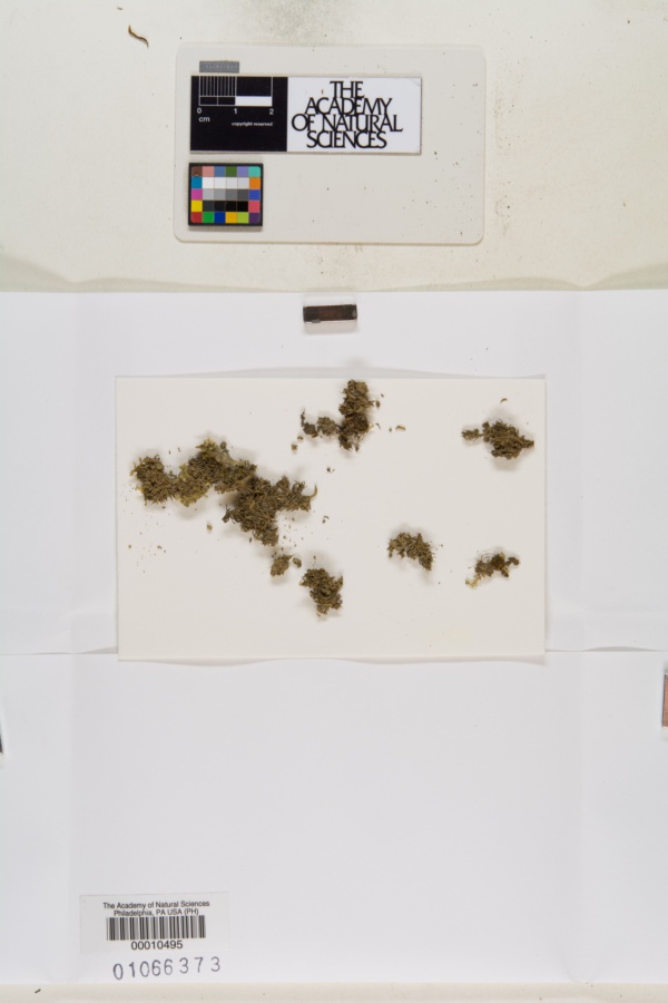
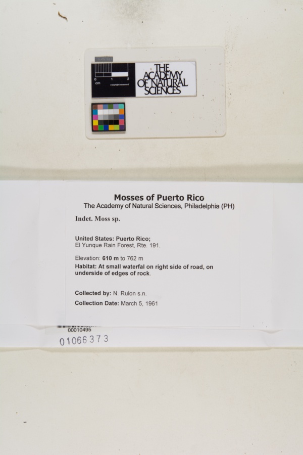
"dwc:recordedBy": "N. Rulon",
"dwc:georeferenceSources": "georef batch tool 2015-12-28; GeoLocate",
"dcterms:references": "https://bryophyteportal.org/portal/collections/individual/index.php?occid=1673652",
"dwc:occurrenceID": "586996cc-432d-4e74-b73e-9c590cd9c8ff",
"id": "1673652",
"dwc:stateProvince": "Puerto Rico",
"dwc:eventDate": "1961-03-05",
"dwc:collectionID": "921fe619-c251-4b3b-9ee4-447c586b44cb",
"dwc:country": "United States",
"dwc:georeferenceRemarks": "Error radius encompasses the El Yunque Rain Forest in Puerto Rico, as shown by ESRI WORLD Topo map",
"symbiota:recordEnteredBy": "James Lendemer",
"dwc:decimalLatitude": "18.285067",
"dwc:georeferenceVerificationStatus": "reviewed - high confidence",
"dwc:maximumElevationInMeters": "762",
"dwc:basisOfRecord": "PreservedSpecimen",
"dc:rights": "http://creativecommons.org/licenses/by-nc/3.0/",
"symbiota:recordID": "586996cc-432d-4e74-b73e-9c590cd9c8ff",
"dwc:habitat": "At small waterfal on right side of road, on underside of edges of rock",
"dwc:locality": "El Yunque Rain Forest, Rte. 191",
"dwc:institutionCode": "PH",
"dwc:catalogNumber": "PH00010495",
"dwc:Identification": [
{
"coreid": "1673652",
"dwc:scientificName": "Indet. Moss sp.",
"dcterms:modified": "2012-07-31 08:42:42",
"idigbio:recordID": "urn:uuid:926007a9-dcbb-43a6-83a5-f72ac739ceb1",
"dwc:dateIdentified": "null"
},
{
"dwc:identifiedBy": "unknown",
"idigbio:recordID": "urn:uuid:d4c042a2-0fd5-4615-85c6-553ff99b547b",
"coreid": "1673652",
"dwc:dateIdentified": "s.d.",
"dcterms:modified": "2023-04-25 00:57:10",
"dwc:scientificName": "Indet. moss"
}
],
"dwc:month": "3",
"dwc:decimalLongitude": "-65.80552",
"dwc:coordinateUncertaintyInMeters": "12463",
"dwc:otherCatalogNumbers": "1066373",
"dwc:georeferencedBy": "R Mazboudi (2015-12-28 07:55:01)",
"dwc:verbatimEventDate": "3/5/1961",
"dwc:recordNumber": "s.n.",
"dwc:minimumElevationInMeters": "610",
"dcterms:modified": "2015-12-28 00:00:00",
"dwc:scientificName": "Indet. moss",
"dwc:day": "5",
"dwc:year": "1961"
},
"indexTerms": {
"recordset": "e39f6dee-f2cf-4eff-afc9-4600cafe660c",
"dqs": 0.2753623188405797,
"stateprovince": "puerto rico",
"catalognumber": "ph00010495",
"startdayofyear": 64,
"collector": "n. rulon",
"uuid": "586996cc-432d-4e74-b73e-9c590cd9c8ff",
"countrycode": "usa",
"basisofrecord": "preservedspecimen",
"institutioncode": "ph",
"mediarecords": [
"8c382bb8-27e1-49f3-9255-6b82aa777405",
"4c52f7de-483c-4e5b-9375-ab319d73b4d6"
],
"datecollected": "1961-03-05T00:00:00+00:00",
"etag": "8a51de704618619466b53b5cfb1cd1be3fd2727f",
"recordnumber": "s.n.",
"minelevation": 610,
"hasImage": true,
"maxelevation": 762,
"collectionid": "921fe619-c251-4b3b-9ee4-447c586b44cb",
"scientificname": "indet. moss",
"locality": "el yunque rain forest, rte. 191",
"hasMedia": true,
"coordinateuncertainty": 12463,
"datemodified": "2023-09-19T17:52:05.919422+00:00",
"occurrenceid": "586996cc-432d-4e74-b73e-9c590cd9c8ff",
"country": "united states",
"geopoint": {
"lat": 18.285067,
"lon": -65.80552
},
"flags": [
"geopoint_datum_missing",
"rev_geocode_mismatch",
"idigbio_isocountrycode_added"
],
"verbatimeventdate": "3/5/1961",
"recordids": [
"e39f6dee-f2cf-4eff-afc9-4600cafe660c\\586996cc-432d-4e74-b73e-9c590cd9c8ff",
"urn:uuid:586996cc-432d-4e74-b73e-9c590cd9c8ff",
"e39f6dee-f2cf-4eff-afc9-4600cafe660c\\1673652"
],
"eventdate": "1961-03-05",
"indexData": {
"dwc:startDayOfYear": "64",
"dwc:recordedBy": "N. Rulon",
"idigbio:uuid": "586996cc-432d-4e74-b73e-9c590cd9c8ff",
"dwc:locality": "El Yunque Rain Forest, Rte. 191",
"dcterms:references": "https://bryophyteportal.org/portal/collections/individual/index.php?occid=1673652",
"idigbio:recordIds": [
"e39f6dee-f2cf-4eff-afc9-4600cafe660c\\586996cc-432d-4e74-b73e-9c590cd9c8ff",
"urn:uuid:586996cc-432d-4e74-b73e-9c590cd9c8ff",
"e39f6dee-f2cf-4eff-afc9-4600cafe660c\\1673652"
],
"dwc:occurrenceID": "586996cc-432d-4e74-b73e-9c590cd9c8ff",
"symbiota:recordEnteredBy": "James Lendemer",
"idigbio:parent": "e39f6dee-f2cf-4eff-afc9-4600cafe660c",
"dwc:stateProvince": "Puerto Rico",
"dwc:eventDate": "1961-03-05",
"dwc:collectionID": "921fe619-c251-4b3b-9ee4-447c586b44cb",
"dwc:country": "United States",
"idigbio:etag": "8a51de704618619466b53b5cfb1cd1be3fd2727f",
"dwc:georeferenceRemarks": "Error radius encompasses the El Yunque Rain Forest in Puerto Rico, as shown by ESRI WORLD Topo map",
"id": "1673652",
"dwc:decimalLatitude": "18.285067",
"dwc:georeferenceVerificationStatus": "reviewed - high confidence",
"dwc:maximumElevationInMeters": "762",
"dwc:basisOfRecord": "PreservedSpecimen",
"dc:rights": "http://creativecommons.org/licenses/by-nc/3.0/",
"idigbio:siblings": {
"mediarecord": [
"8c382bb8-27e1-49f3-9255-6b82aa777405",
"4c52f7de-483c-4e5b-9375-ab319d73b4d6"
]
},
"symbiota:recordID": "586996cc-432d-4e74-b73e-9c590cd9c8ff",
"flag_idigbio_isocountrycode_added": true,
"dwc:habitat": "At small waterfal on right side of road, on underside of edges of rock",
"idigbio:dateModified": "2023-09-19T17:52:05.919422",
"dwc:georeferenceSources": "georef batch tool 2015-12-28; GeoLocate",
"dwc:institutionCode": "PH",
"dwc:catalogNumber": "PH00010495",
"dwc:Identification": [
{
"coreid": "1673652",
"dcterms:modified": "2012-07-31 08:42:42",
"dwc:scientificName": "Indet. Moss sp.",
"dwc:dateIdentified": "null",
"idigbio:recordID": "urn:uuid:926007a9-dcbb-43a6-83a5-f72ac739ceb1"
},
{
"dwc:identifiedBy": "unknown",
"idigbio:recordID": "urn:uuid:d4c042a2-0fd5-4615-85c6-553ff99b547b",
"coreid": "1673652",
"dwc:dateIdentified": "s.d.",
"dcterms:modified": "2023-04-25 00:57:10",
"dwc:scientificName": "Indet. moss"
}
],
"dwc:month": "3",
"dwc:decimalLongitude": "-65.80552",
"dwc:scientificName": "Indet. moss",
"dwc:otherCatalogNumbers": "1066373",
"dwc:georeferencedBy": "R Mazboudi (2015-12-28 07:55:01)",
"dwc:verbatimEventDate": "3/5/1961",
"dwc:recordNumber": "s.n.",
"idigbio:isocountrycode": "usa",
"dwc:minimumElevationInMeters": "610",
"dcterms:modified": "2015-12-28 00:00:00",
"dwc:coordinateUncertaintyInMeters": "12463",
"dwc:day": "5",
"dwc:year": "1961"
}
},
"attribution": {
"uuid": "e39f6dee-f2cf-4eff-afc9-4600cafe660c",
"name": "Academy of Natural Sciences of Drexel University - Bryophytes",
"description": "PH (the official, internationally recognized abbreviation for the herbarium at the Academy of Natural Sciences) is the oldest institutional herbarium in U.S. It is a national resource for material from 1750-1850, with some dating from as early as 1689.",
"logo": "https://bryophyteportal.org/portal/content/collicon/ph.jpg",
"url": "http://www.ansp.org/research/systematics-evolution/collections/botany/",
"emllink": "https://bryophyteportal.org/portal/content/dwca/ph_dwc-a.eml",
"archivelink": "https://bryophyteportal.org/portal/content/dwca/ph_dwc-a.zip",
"contacts": [
{
"email": "BryophyteConsortium@gmail.com"
},
{
"email": "BryophyteConsortium@gmail.com"
},
{
"email": "ans_ph_herbarium@drexel.edu"
},
{
"first_name": "Chelsea",
"last_name": "Smith",
"role": "Collection Manager",
"email": "ans_ph_herbarium@drexel.edu"
},
{
"first_name": "Chelsea",
"last_name": "Smith",
"role": "Collection Manager",
"email": "ans_ph_herbarium@drexel.edu"
}
],
"data_rights": "CC3 BY-NC",
"publisher": "4e1beef9-d7c0-4ac0-87df-065bc5a55361",
"totalCount": 57488
}
}
 PH (the official, internationally recognized abbreviation for the herbarium at the Academy of Natural Sciences) is the oldest institutional herbarium in U.S. It is a national resource for material from 1750-1850, with some dating from as early as 1689.